

Over the past few years that I’ve worked as an engineer for Simpson Strong-Tie in Texas, work-related events have brought me to a few great beach destinations: Clearwater and Destin, Florida, to name a few. But tightly packed schedules always left me feeling like I didn’t get to enjoy the fullness of the locations I visited. So I made a short-term goal to fulfill a bucket-list item: Enjoy a beach vacation.
Not long after setting that goal, I actually had an opportunity to visit the Bahamas. Unfortunately, it wasn’t for the beach vacation I imagined, but rather to survey the catastrophic destruction wrought by Hurricane Dorian. With the one-year anniversary of that hurricane on September 1 and hurricane season already hitting us hard with Hurricane Laura, I thought it would be good to revisit my observations from that trip.
We are still gathering information about the extent of damage from Hurricane Laura and there will likely be field assessment teams dispatched to the hardest hit areas. That was the case in 2019 after Hurricane Dorain struck. Soon afterward, I was invited to join a field damage assessment team by my colleague Tracy Kijewski-Correa, Professor at the University of Notre Dame and Director of the Structural Extreme Events Reconnaissance (StEER) Network. I was familiar with damage assessment and had joined this organization as a member after being involved with similar assessments following Hurricanes Harvey and Michael.
When I announced I was participating on the team, the natural reaction of friends and co-workers was “you’re going to the Bahamas!” It was the same thought I briefly entertained when I accepted the invitation to go. Of course, I knew it wouldn’t all be crystal blue water, white sands, and palm trees, but the reality check started with the trip preparations. We were encouraged to get vaccinations, told to prepare for conditions without food and water provisions, advised there would be limited room for our luggage on the required chartered planes, and informed of media stories about missing people and foul stench areas causing sad speculations.
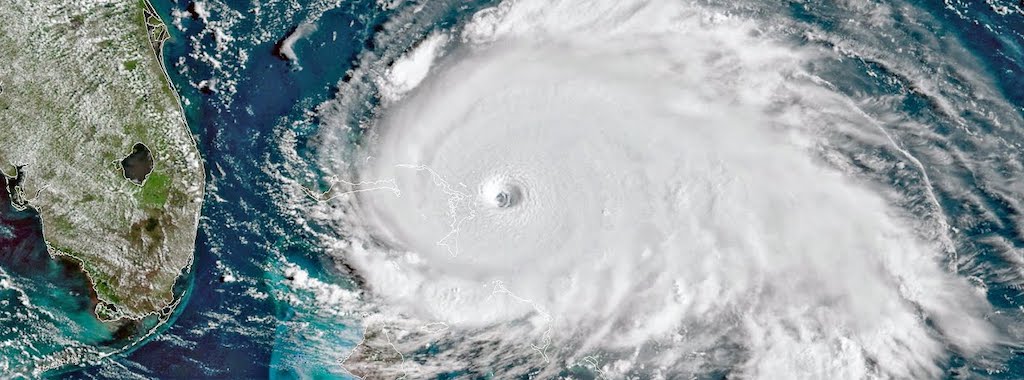
As you may recall, Hurricane Dorian made landfall at Elbow Cay in the Abaco Islands on September 1, 2019, as a Category 5 hurricane with maximum sustained winds of 185 mph and gusts up to 225 mph. Those were the strongest sustained wind speeds recorded for an Atlantic hurricane that had made landfall since 1935. Dorian made landfall again on Grand Bahama, where it remained for approximately 24 hours before departing as a much-weakened storm to the northeast.

Virtual Damage Assessment
Directly following the event, the StEER Network completed a virtual assessment of the destruction and assembled two teams of volunteers to conduct field assessments. That work resulted in two reports, the StEER Preliminary Virtual Reconnaissance Report (PVRR) and the StEER Early Access Reconnaissance Report (EARR). Together, these two reports help provide an overall understanding of the magnitude, scope, impact, and characteristics of the storm, as well as the extent of the destruction left in its path. Additionally, StEER has provided unprecedented Data Access, which includes powerful visuals, street views, and Fulcrum App entries.
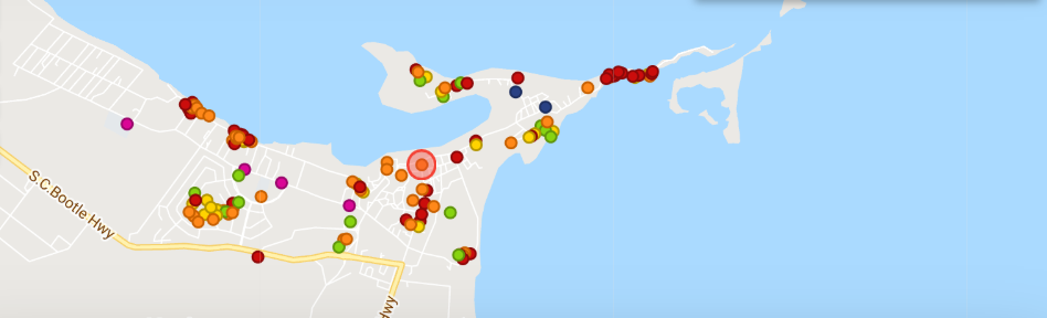
The varying degree of performance is color coded in the image below (additional detail in the Data Access link above). This image is from the Fulcrum App that was used to aid our documentation and organization of targets and assessments.
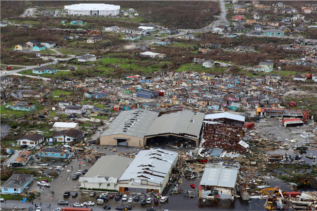
Similar to most strong hurricane events, damage was caused by a combination of high wind, storm surge, and flooding. Hurricane Dorian devastated nearly everything in its path. Storm surge exceeding 20 feet smashed unreinforced masonry walls to the ground and displaced enormous boats from cozy slips to over a kilometer from the shoreline. One resident pointed to his blue F-150 truck 200 feet away as he explained that we stood in the place it was parked when the storm hit the islands. The unprecedented high winds ravaged everything above the surface of the water, being most destructive when the envelope of the structure was penetrated. Broken windows, missing doors or walls resulted in the loss of the roof almost without exception. Once the roof was damaged or removed, driving rains and airborne debris destroyed much of what was remaining inside the structure.
As with any community, there are different types of structures: government, commercial, and residential, each of which “performed” differently during the storm depending on the building type, age, geometry, and material, as well as the level of exposure. Due to these many variables, a broad data set was required to accurately evaluate commonalities, themes, and trends correlating design and construction practices to performance. StEER deployed field assessment groups to collect these needed data points.
First Field Assessment
The first Field Assessment Structural Team (FAST-1) deployed September 24-26 and completed door-to-door assessments and Applied StreetView imaging across Marsh Harbour and Treasure Cay, on Great Abaco Island. Their strategy centered on predetermined clusters of structures based on typology, year of construction, post-Dorian performance (as indicated by satellite imagery), and hazard intensity. Both Marsh Harbour and Treasure Cay were within the eyewall of Dorian, suggesting that the wind speed gradient would not be substantially different between the two regions. However, storm surge and wave action still varied substantially across these regions depending on distance inland and local topography. FAST-1 documented performance under a variety of storm surge heights based on initial eyewitness reports.
Based on StEER’s initial assessment, they recommended that the second team should focus on more in-depth study in several areas, including revisiting well-performing sites, such as the Marsh Harbour Medical Clinic and government building, mapping gradients of the storm surge inundation in more detail, and broadening the assessments geographically to include structure performance in surrounding cays and in Grand Bahama.
Second Field Assessment
The second field assessment team of volunteers, comprising practitioners and researchers, including Bahamian engineers (Davon Edgecombe, P.E., Terran Brice, and Kevin Brown), deployed October 5-8. This FAST-2 team, of which I was a part, was organized under three sub-teams: coastal survey, door-to-door damage assessments, and rapid imaging. We all worked in parallel assessing strategic targets, mapping coastal storm surge, rapidly imaging developments with significant wind and storm surge damage using 360-imaging and Applied StreetView technologies, and conducting in-depth forensic assessments using StEER’s mobile applications and LiDAR scanning. The geographic coverage included Great Abaco Island, Man-o-War Cay, and Grand Bahama Island.
It was a unique experience to travel to an international vacation destination renowned for its beautiful white sandy beaches and crystal blue waters, but now decimated by a Category 5 hurricane. Stepping off our charter plane, the reality of the devastation was everywhere.
We walked off the tarmac to the one-room customs office building with a severely damaged airplane hangar in the distance. After customs, we piled into dilapidated vehicles with bald tires that had somehow survived the storm. We stayed at what was left of a former resort that was without power or running water for two of the three nights we were there. All of these challenges and discomforts, however, dissipated to nothing as we became aware of the devastation that displaced 70,000 inhabitants from the islands.
In Abaco, we observed that standing seam metal roofs generally performed well. Standard roofing practice on the Bahama Islands is ¾” nominal sheathing installed with 10d nails. The sheathing is topped with an ice and water shield and then roofing cover is installed. On a few government structures where the asphalt shingles had been damaged, there was no visible water damage inside. The best-performing roof finish was termed Bermuda roof, consisting of insulation with a cementitious layer, as seen below on the Commonwealth Commercial Bank.
In our door-to-door assessments, we noted shutters, sliding glass doors, and windows that had track systems were more susceptible to failure. We also talked to a homeowner who recounted how a sliding glass door dislodged from its track and struck him in the head when he was taking shelter 20′ away under the kitchen table.
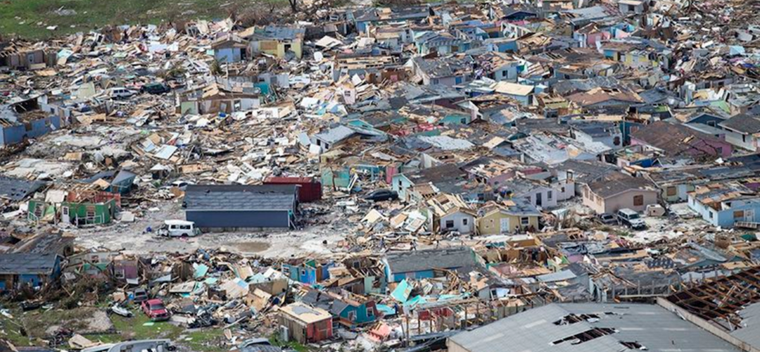
There are some insights to gain from the above photo. The structures that were government buildings (for example, the white building in the upper right) or structures built with great effort and intention performed very well. At the other end of the spectrum are the “informal settlements” shown in the middle of the photo, an area known as muddy peas that was considered a “slum” area where there were no building permits, no construction standards, and no conventional construction practices. The devastation of this area was the most heart-wrenching, because there was nothing of significance that survived.
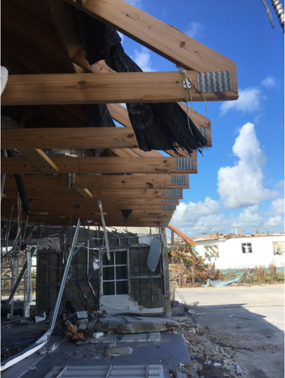
On my first day, the Bahamian engineers and I conducted the door-to-door assessments. We visited 13 island locations that included government buildings, churches, and a school, as well as retail and residential areas. We observed many examples of wood truss failures where the bottom chord or top chord was literally split in two down the length of the member several feet. The chords would simply shear near the bearing location. In instances where hurricane clips or ties were present, they lacked nails or proper nails into framing members. Almost all roof framing failures were accompanied by a failure of the envelope — i.e., broken windows, collapsed walls, garage door failures, etc.

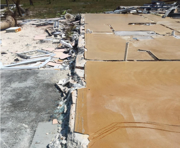
This structure was swept off its foundation, roof collapsing to the ground as the walls folded underneath. Dorian uprooted this building at its anchorage points along the perimeter of the foundation. Anchor bolts with insufficient embedment depths left scratch marks across the slab as the structure was pushed about 80 feet to its new location as seen in the adjacent photos. All too often, concrete anchorage considerations are overlooked or deferred to be solved later. We are frequently asked what post-installed solutions are available for anchoring relatively large loads near the edges of concrete slabs or foundations.
Commonwealth Commercial Bank
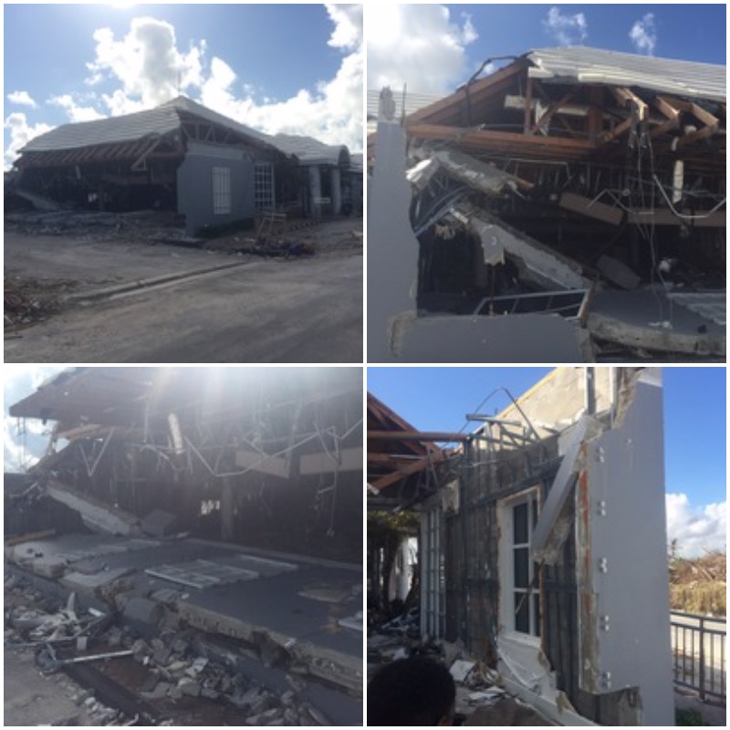
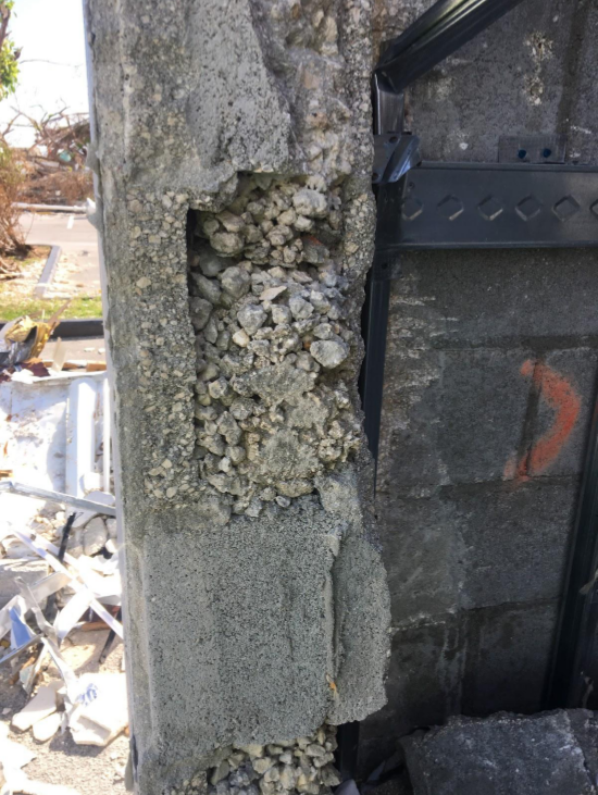
As we inspected the Commonwealth Commercial Bank in Marsh Harbour, we observed severe damage of the structure where the end wall fell inward from positive pressure. This reinforced masonry structure with engineered wood trusses and a “Bermuda roof” finish performed relatively well compared to the neighboring structures. Partial failures such as these offer us more insights than structures that performed well without any damage or those that were completely destroyed. Partial damage leaves us clues as to where, why, and how the structure is susceptible to damage. It gives us a cross section of the construction assembly that we otherwise wouldn’t be able to observe. There’s often a belief that engineered structures have unnecessary added cost from overly-conservative designs. Also, we know that buildings often incorporate some structural redundancy, which makes failures “interesting” to inspect, sometimes remarkably still standing without a recognizable adequate support. Similar to other failures, the damage of the Commonwealth Commercial Bank was actually the result of multiple factors occuring simultaneously:
- Category 5 Hurricane
- Exposure Category D
- Poor grout mix and consolidation
- Inadequate development length for splices in mild steel reinforcement
- Large opening at the end of the wall where out-of-plane shear was greatest
- CMU wall wasn’t designed to span vertically or horizontally
- CMU wall wasn’t braced out of plane at the top of the wall by the trusses
Observations and Continuing Objectives
It’s remarkable how much construction practices vary depending on geography. Here in the US, for example, some areas use post-tensioned slabs on grade exclusively. In some areas, it’s common to use only “stick frame” roofs. Brick foundations are common in North Carolina, but clay masonry isn’t considered structural in any other part of the country. Southern Florida commonly uses grout-filled CMU for all first-floor walls. The variability makes it challenging to give solutions that work for every community, but there are usually still some commonalities.
My general objective as a licensed structural engineer for Simpson Strong-Tie is to see what worked and what didn’t work — to identify specific successes and failures, and try to learn anything we can about the performance of structures, life safety issues, or vulnerabilities that exist in construction standards or practices, etc. With this understanding, we can then be more apt in developing new products, modifying common design or construction practices, educating building officials and builders alike, and communicating with the design industry about improved solutions.
It’s my hope that the data sets and findings included in our reports will help our global engineering community design and build stronger structures, particularly in high-wind areas.
My beach destination trip anchored me more deeply in the importance of what we do as a company and my role specifically. When these high-wind events occur, our company takes the responsibility to learn as much as possible about what we can do to aid builders by providing innovative products or processes that will help make structures stronger and safer for their owners and inhabitants.
